Two very different visits on one headland: an easy clifftop, and a lighthouse that asks a great deal more.
CHECK FIRST · ACCESS
South Stack is weather-dependent: island access and lighthouse tours can close at short notice, and reaching the light means a steep descent of around 400 steps. Check current lighthouse access before you set off. The clifftop viewpoints are worth it either way.
Time needed
45–90 min for the cliffs · 2–3 hr with the lighthouse tour
Best time
Spring for breeding seabirds · choughs all year
Opening, entry & booking
Reserve free, all year · car park charged · lighthouse and its steps only at advertised times
Access & difficulty
Easy at the upper viewpoints · ~400 steps down to the lighthouse
Parking & start point
RSPB South Stack visitor centre & car park, near Holyhead
Getting there
Holyhead station ~3 miles · no reliable bus, so car or taxi
Toilets, food & facilities
RSPB café, shop & toilets · none on the lighthouse island
Dogs
Welcome on the reserve · not inside the café
Plan with confidence.Detailed information on arrival, access, facilities, restrictions and local conditions.
Opening, entry & booking
South Stack is two separate operations on one headland, run by different bodies to different timetables. The clifftop is RSPB South Stack Cliffs; the island and the lighthouse itself are run by South Stack Ynys Lawd Ltd under licence from Trinity House. Neither one opening tells you about the other.
Reserve & cliffs (RSPB)
Open all year, free to enter. The cliff paths and viewpoints are not gated.
Car park (RSPB)
The reserve car parks. Charges apply year-round, including to members on some tariffs. No overnight parking or camping. 7 Blue Badge bays.
Visitor centre, café & shop (RSPB)
Shorter hours than the reserve: they are not open whenever the cliffs are. Check the current times before relying on a hot drink.
Toilets (RSPB)
Open seven days a week, 10am–5pm, at the visitor centre only. None at Elin’s Tower and none on the island.
Lighthouse island & tours (Ynys Lawd / Trinity House)
Open only at the times its operator, South Stack Ynys Lawd Ltd, advertises: outside them there is no access to the island or to the steps down to it. Check Trinity House’s South Stack Lighthouse page, which points to the operator’s times, before you travel.
Tickets & booking
Bought on the day from the kiosk in the RSPB car park, next to the café. Card preferred. Buy at least 60 minutes before your tour; the kiosk shuts 30 minutes before the last tour. Groups of 10 or more must pre-book.
Closing early
Lighthouse admission can shut before the advertised time on a daily risk assessment based on footfall and capacity inside the tower. The published closing time is a ceiling, not a promise.
Use the RSPB South Stack car park by the visitor centre. Parking charges can change, so go by the current RSPB charges page rather than older figures.
Public transport & car-free access
Car-free access to South Stack is possible, but it needs planning. The nearest useful rail station is Holyhead, around 3 miles from South Stack according to Trinity House, with onward travel by taxi, bike or a long walk. Don’t assume there is a convenient bus to the lighthouse itself; services vary. The final lighthouse visit also involves a steep descent of around 400 steps, and island access depends on advertised opening hours and conditions.
RSPB toilets, an accessible toilet and baby-change are at the visitor-centre area, alongside the café and shop. There are no facilities on the lighthouse island, and no toilets in Elin’s Tower.
Accessibility & terrain
Level route
From Elin’s Tower car park to the viewpoint outside Elin’s Tower.
Centre to Elin’s Tower
The route between the visitor centre and Elin’s Tower has 25 uneven steps.
Coastal trail
More rugged, uneven and narrow.
The lighthouse
Not step-free: see the descent details above.
Plan around it
The upper viewpoints suit far more visitors than the descent does.
Dogs & restrictions
Dogs are welcome on the RSPB reserve and in Elin’s Tower, but not inside the café; assistance dogs are welcome in all parts of the reserve. Keep dogs under control and stick to the paths. Access rules for the lighthouse island are set by the lighthouse operator, so don’t assume you can take a dog across.
Safety, weather & local conditions
This is an exposed cliff landscape: wind, uneven paths, steep steps and moving sea. Wear proper footwear, keep back from cliff edges, watch children and dogs, and don’t start the descent if the weather or your footing feels wrong. Exposed coast: in an emergency call 999 and ask for the Coastguard.
RSPB operates a no-drones policy on the reserve from 1 March to 31 July to protect breeding birds.
Main planning gate
Weather & island access · tours are not guaranteed
Forecast
Wind and visibility decide whether the descent is sensible. Check the Met Office forecast for Holyhead, the nearest station, a couple of miles east and at sea level, so expect more wind on the cliff steps.
PLACE-SPECIFIC DETAILS
Lighthouse tours
Operator
South Stack Ynys Lawd Ltd, under licence from Trinity House, not the RSPB, whose reserve you cross to reach it.
Tour length
About 20–40 minutes, depending on group size.
To climb the tower
Minimum height 1.1 m.
Getting down
Around 400 steep steps to the bridge, then the same climb back; there is no other way off the island.
When it closes
Weather permitting; island access and tours can close at short notice. Timetable and ticketing are in Opening, entry & booking above.
The RSPB café and shop sit by the visitor centre, and keep the visitor centre’s hours rather than the reserve’s, and the cliffs stay open long after the counter shuts. Dogs are not allowed inside. Carry water for the cliffs and the steps rather than counting on it.
Other place details
Car-free
Difficult without a car; car recommended
What to bring
Water
Windproof layer
Sturdy footwear
Binoculars optional
Charged phone
Card for parking
Sun or rain cover
Atlas of Wales Discovery Highlight
The landmark is below you.
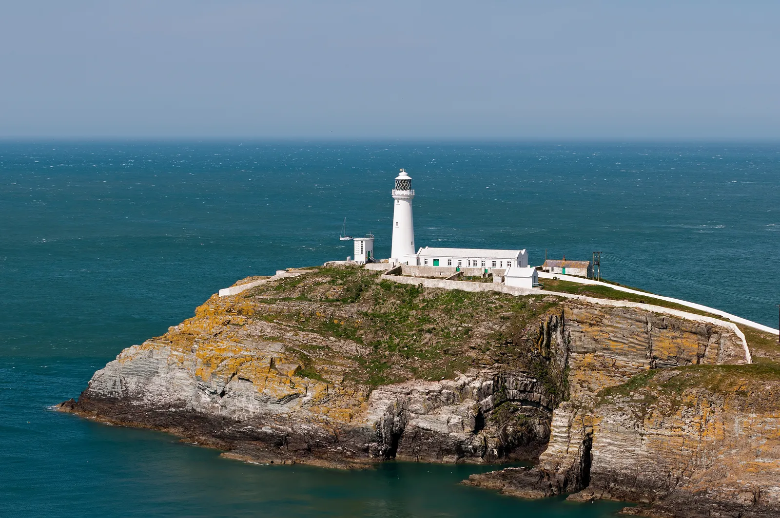
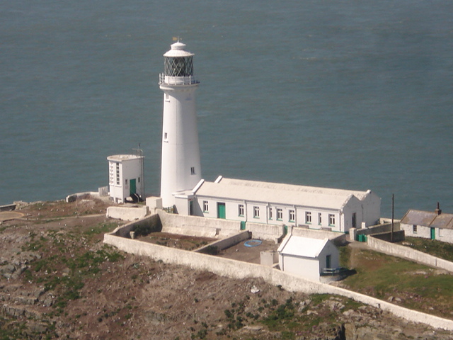
Most lighthouse visits build towards a tower on the horizon. South Stack does the opposite. You arrive high on the cliffs, then look down: white walls, the bridge, sea moving in the gap, and the Irish Sea opening beyond.
The visit becomes a descent, from heathland and cliff edge down to a working sea light.
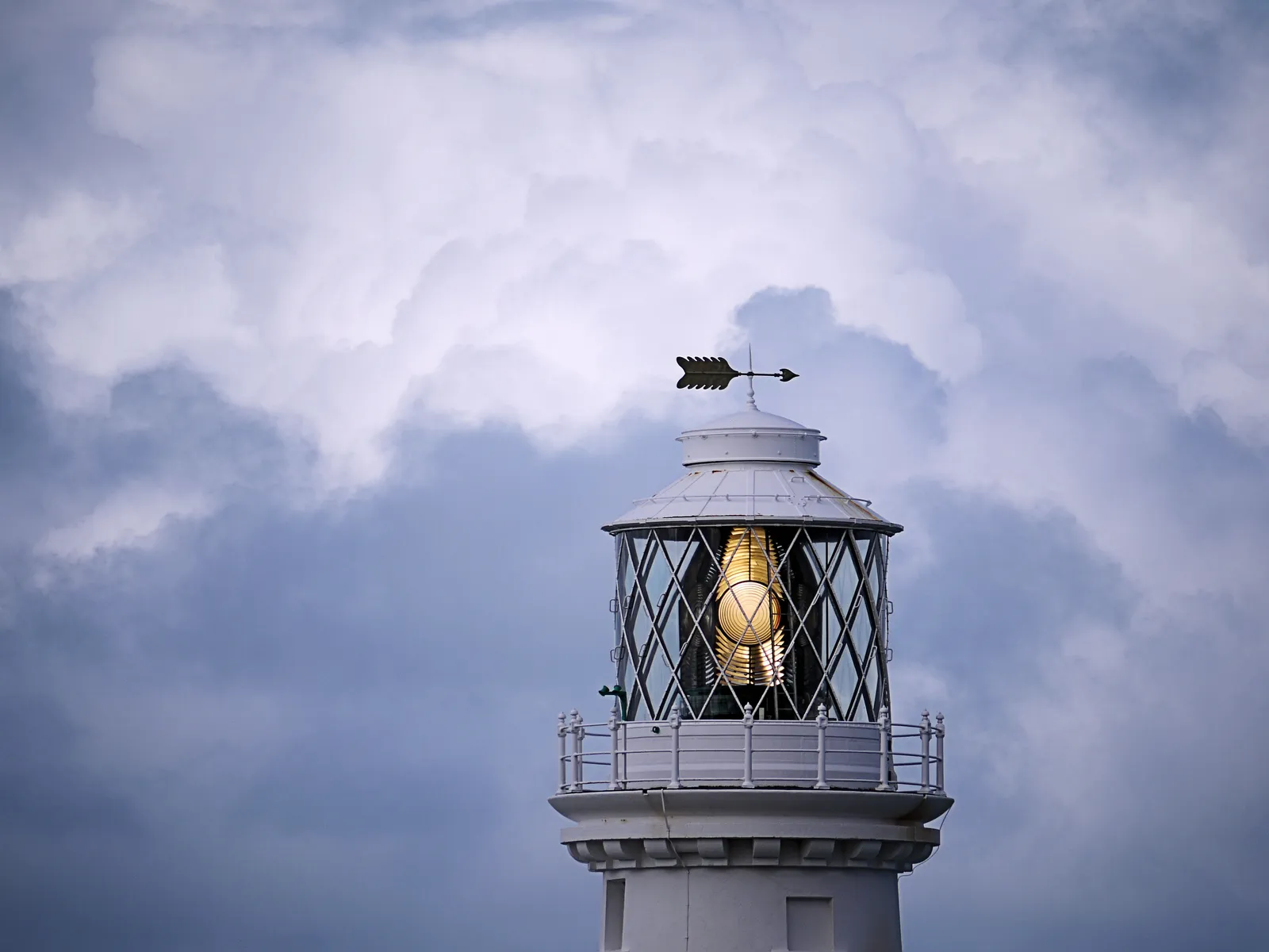
The lamp room, lit above the cliff edge.
Atlas of Wales Verdict
Should this shape your day?
Worth it for the edge-of-Anglesey drama, not for a casual flat stroll.
Good fit for
lighthouse & coastal photography
dramatic Anglesey viewpoints
spring seabirds and choughs
walkers happy on exposed cliff paths
anyone happy to plan around the weather
Think twice if
you need step-free access to the lighthouse
you dislike exposed cliff edges or strong wind
you want a low-effort visit with very small children
you’re bringing a dog and specifically want the lighthouse island
you’re relying on public transport and haven’t planned the stretch from Holyhead
Weather & access decide the day
the upper viewpoint and Elin’s Tower are far easier than the descent
tours and island access can close at short notice
car-free is possible, but the final stretch needs planning
Elin’s Tower and the cliffs first, then the descent, only if it’s open and conditions feel sensible.
When the light earns its name: South Stack at sundown.
How your visit unfolds
One descent, seven scenes.
See the shape of the visit before you commit to the steps.
01 Arrive
Clifftop car park, RSPB centre, first taste of the wind.
02 The edge
Sea on three sides, open sky, the cliffs falling away.
03 Elin’s Tower
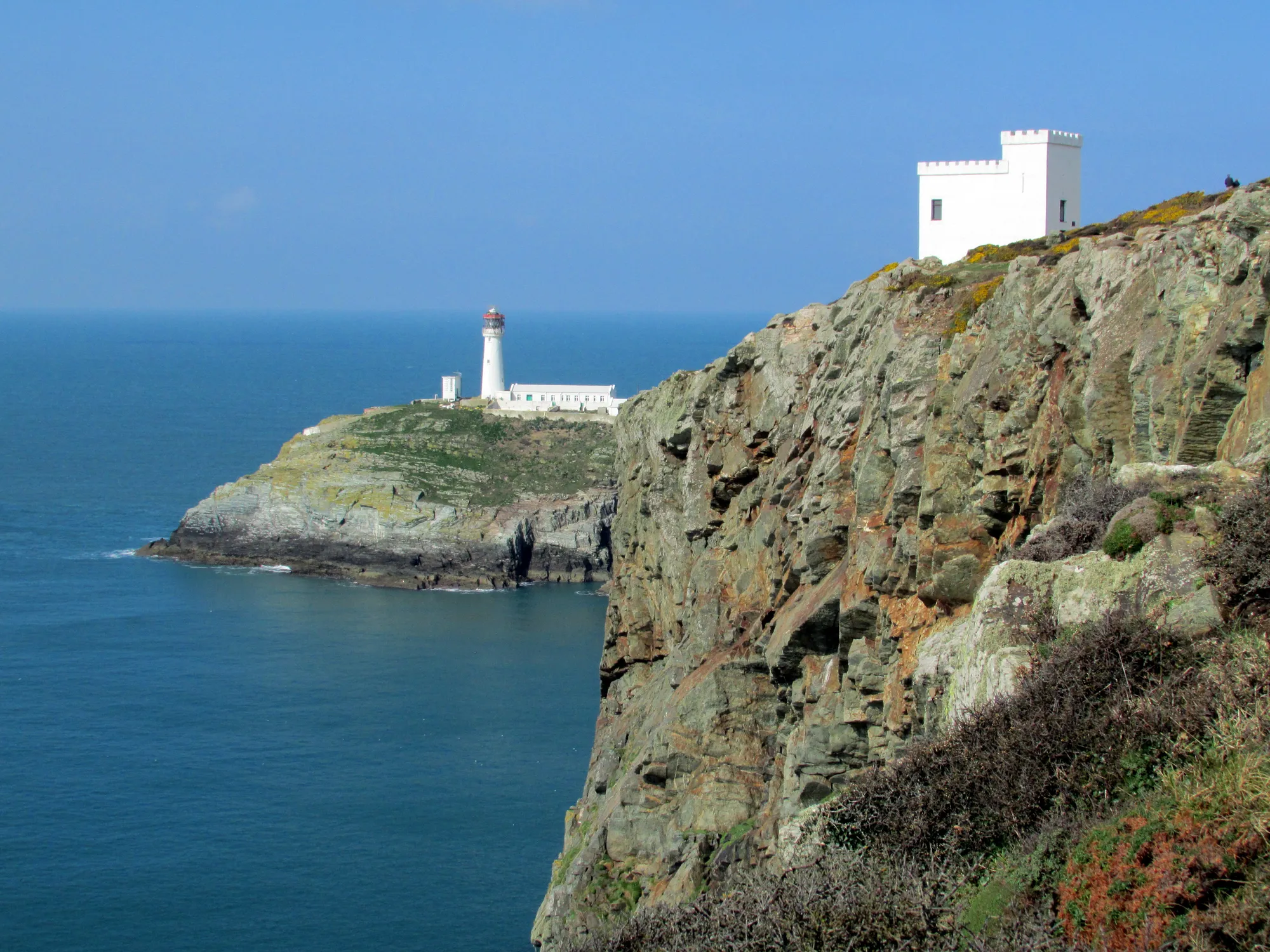
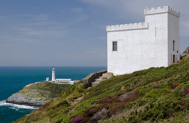
The classic view: white tower and island far below.
04 The steps
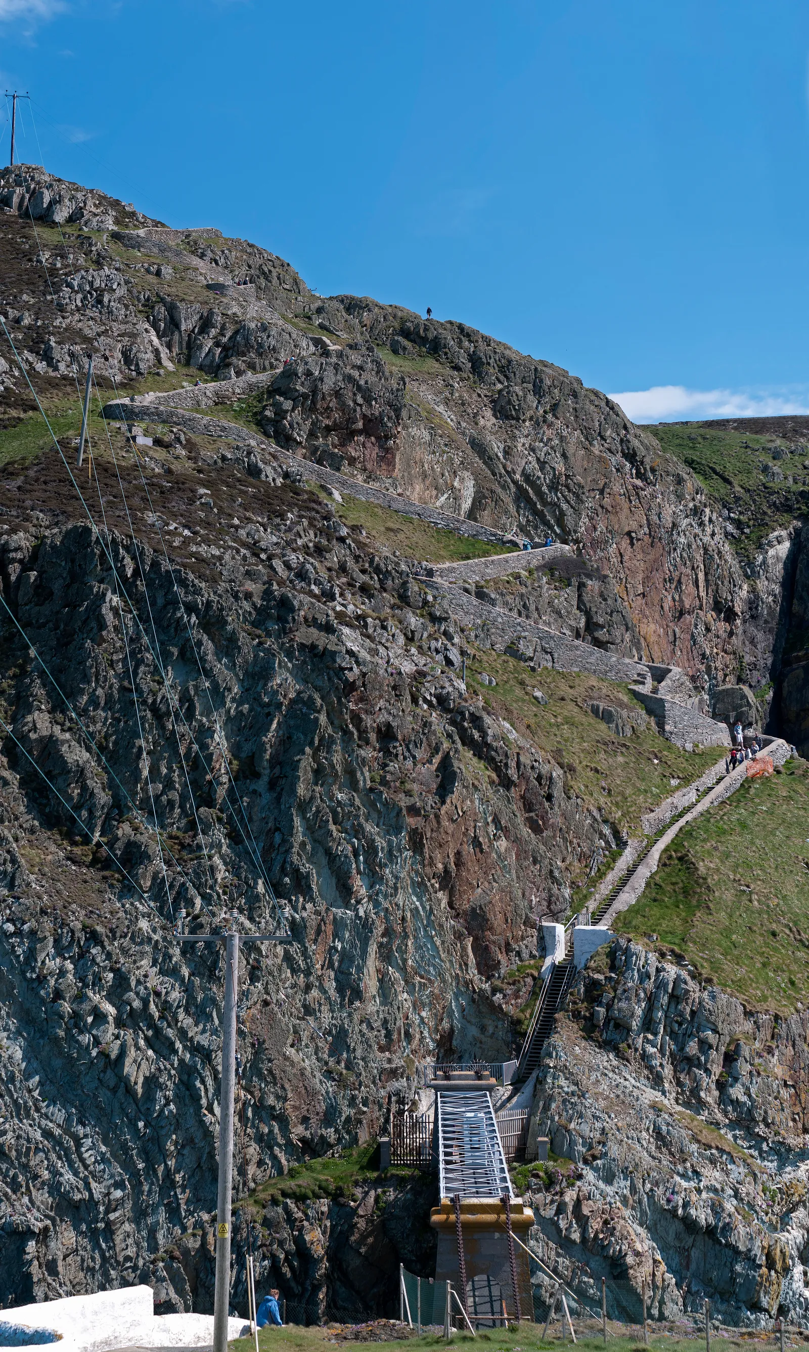
Around 400 of them, switchbacking down to the bridge.
Access check essential
05 The bridge
A short crossing over moving sea makes the gap real.
06 The light
Lantern, lens and keepers’ story: a working sea light.
07 The birds
Climb back slowly, then give the cliffs time.
South Stack, in pictures
Seen from the cliffs.
Tower, bridge, steps and sea: the visit before you make it.
The way down: around 400 steps and the footbridge to the islandThe lighthouse from the cliffs, sitting below youThe lantern lit, at the top of the towerThe light and the keepers’ quarters on the rockElin’s Tower country: the seabird cliffs and the light beyond
What stays with you
The parts people remember
You arrive at the top of this one. The lighthouse, the bridge and the birds are all somewhere under your feet.
01
Looking down at a lighthouse
You are used to lighthouses on the skyline. This one sits under you, small and white against the water, before you have walked a step towards it.
02
The steps turn back on themselves
The way down folds against the cliff, so the tower keeps swinging in and out of view as you drop.
03
Water moving under the bridge
The crossing takes seconds. It is the sea running through the gap beneath it that makes the island feel like an island.
04
The noise off the cliff face
In season the sound arrives before anything else does, coming up the rock from ledges you cannot see from the path.
05
The climb back
Around 400 steps down to the bridge, and the same 400 back up, because there is no other way off the island. You spend the time at the bottom knowing exactly what the return costs. Worth planning the visit around the climb rather than the other way round.
Around four hundred steps down, and the same four hundred waiting for you afterwards.
From the South Stack archive
A light, a gap, and a reserve.
Four field notes on what South Stack is: the 1809 light, the crossing, the seabird cliffs, and the working light today. Source-backed, and where sources differ the note says so.
This is history kept honest. Where a date or detail is uncertain, it is flagged as uncertain rather than smoothed into a confident guess.
Field notes
Four entries. Open one to read the note.
The lighthouse Fact
A light first shown in 1809
Field note I · filed under the lighthouse
Trinity House built South Stack to mark the rock off Holy Island, and first showed its light on 9 February 1809.
What is known
Trinity House built the lighthouse in 1809 to mark South Stack Rock off the Anglesey coast, and its light was first shown on 9 February 1809. It was designed by the Trinity House surveyor Daniel Asher Alexander.
What the numbers say
Trinity House lists the tower as 28 m high and the light as 60 m above Mean High Water. Other accounts sometimes quote figures differently, so go by the official Trinity House page.
What to notice there
From the cliff path the tower reads small against the sea. The scale only lands once you start down the steps towards it.
The gap Fact
The crossing
Field note II · filed under the bridge
South Stack Rock is separated from Holy Island by around 30 metres of turbulent sea, and getting across has always been the problem to solve.
What is known
South Stack Rock sits about 30 metres off Holy Island, with fast, turbulent water in the gap. Reaching the lighthouse today means descending roughly 400 steps and crossing a bridge when access is open.
The bridge over time
A bridge has spanned the gap since the nineteenth century and has been rebuilt more than once; an early suspension bridge is recorded here. Exact dates and rebuild history vary between sources.Bridge dates · sources differ
What to notice there
The crossing is short, but the moving sea beneath it makes the separation from Holy Island feel real.
The reserve Fact
The seabird cliffs
Field note III · filed under the reserve
South Stack is also an RSPB reserve: heathland, farmland and rocky sea cliffs that matter for seabirds, not just a lighthouse photo stop.
What is known
RSPB South Stack Cliffs takes in heathland, farmland and rocky sea cliffs, and is important for seabirds. RSPB says the cliffs are a breeding ground for guillemots, razorbills and puffins in spring, and choughs can be seen along the cliffs all year.
When to come
Spring and early summer are busiest for breeding seabirds; the choughs are the year-round constant. Elin’s Tower, the RSPB seabird hide, sits right on the cliffs.
What to notice there
Bring binoculars. The cliffs are loud and active in season, and the choughs (red-billed, acrobatic) are worth learning to spot.
Now Fact
The working light today
Field note IV · filed under operation
South Stack is no longer a place where keepers live; the light is automated and remotely operated.
What is known
The lighthouse is now automated and monitored remotely rather than staffed by resident keepers. Trinity House operates it as a working aid to navigation, and runs the visitor tours when conditions allow.
Where sources differ
Accounts disagree on the exact year, partly because “automated” and “keepers withdrawn” are not always the same date. Treat any single year with caution.Automation date · sources differ
What to notice there
It still earns its keep. The tour focuses on the lantern, the lens and the working maritime purpose, not nostalgia.
Continue exploring
Don’t let the day end at one pin.
Four stops that turn one lighthouse into a Holy Island day.